Friday, December 16, 2011

Holiday Traditions Afloat

Posted: December 13, 12:33 pm | (permalink) | (0 comments)
Every community has their holiday traditions, and the boat community is no exception. At our marina in Annapolis, the boaters get together every year for a holiday party. “White Elephant” gifts with a nautical theme are exchanged (over the years we’ve seen a stuffed lobster that sang Jingle Bells; nautical charts 20 years out of date and hence guaranteed to get you lost; a battered, dented air horn; even a kit to build a ship model in a bottle). There’s a table set aside with craft supplies and plain ornaments. During the party, each person hand-decorates an ornament with the name of their boat and the date, and hangs it on the tree in the lounge. At Gangplank Marina in Washington DC, some of the liveaboards go boat-to-boat by dinghy and kayak, singing carols and serenading the neighbors. And as the Jimmy Buffett song says, we hang our stockings from the mast. But my favorite tradition has always been the boat parades.


I should explain that I’ve always been a sucker for twinkling holiday lights. When I was a little kid, I’d beg my parents to take me to the top of the Empire State Building (at the time, the tallest building in New York City) to see “all the lights there ever were;” and to this day, no matter where we’ve lived, I’ve made a holiday tradition of walking or driving around town looking at lights. Since we’ve moved aboard, that tradition has extended to boats. Boats are naturals for strings of holiday lights; you can simply twine them around the lifelines or hoist them up the mast. We’ve seen lots of lighted boats, some very elaborate and some very simple. In some cases (best they remain nameless) people have gone over the top with their decorations solely for the bragging rights, but the vast majority of people I’ve met, when asked why they take their boat out to drive in circles in the cold and dark after spending hours (weeks?) decorating, have the same answer as my friend Christy Tinnes & Frank Florentine quoted here in the Capital last week: “To give something back to the community.” And the community has always been appreciative.


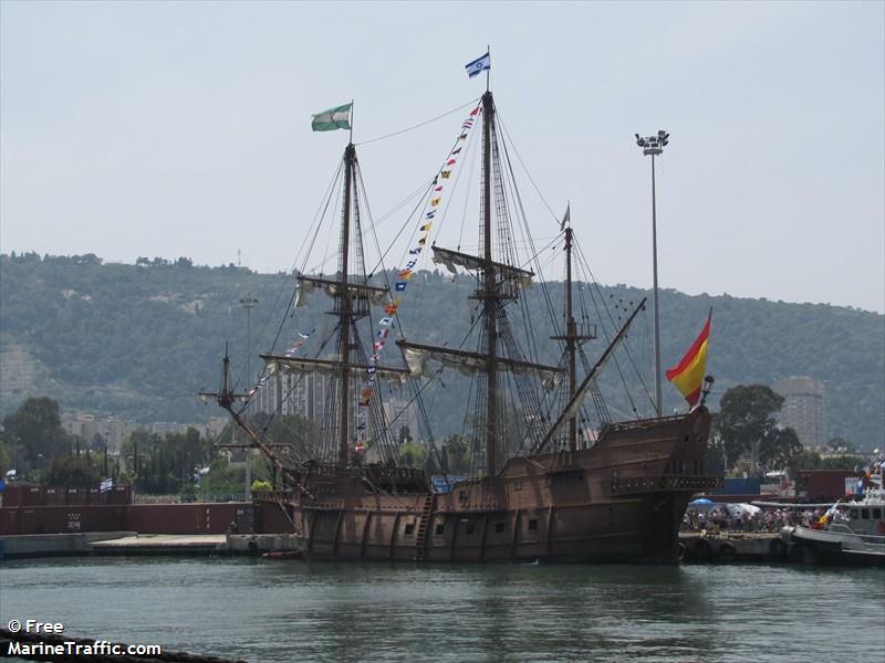
On the same evening that lighted boats were circling the Annapolis harbor for the Eastport Yacht Club Lights Parade, lighted boats were circling the harbor here in St Augustine too, and we wanted to join the festivities. Although about 20 degrees warmer than Annapolis, <*insert smug grin here!*> the harbor was unfamiliar to us, with lots of shoals and strong currents, and the night was windy, so we decided it would not be prudent to take our own boat. Instead, we signed up to join the jolly pirates on the day charter boat “Black Raven” just a few slips away from us here at the marina. We pulled out of the slip and through the bridge, and waited at the designated place for the signal that would start the parade. Not being content with a mere starting gun to begin the event, the City fired a cannon from the old Castillo, the Spanish fort overlooking the harbor … and we, in the spirit of being a pirate ship and all that, turned to fire back at them before leading the city’s “Holiday Regatta of Lights” past the judges stand and past a seawall that seemed densely packed with the entire twelve thousand plus population of the town. The skipper, Rosaire Caron, a.k.a. “Captain Corona,” warned us at the outset that weather conditions were going to make the trip challenging for a boat of the Raven’s size, and if the weather deteriorated or if he felt it was too risky, we’d abandon the parade and come back in early. But we’d give it a try, because, well, “it’s the parade,” he said, as though that explained it all. Maybe it did; it’s that giving back to the community thing again, that made it worth just a bit of extra effort.


[photo: Boats circling in the harbor before the event]

[photo: Black Raven decked out in lights from the 2010 parade; property of Black Raven; used by permission]

A History Lesson

Posted: December 8, 12:19 pm | (permalink) | (0 comments)
You’ve seen them on Main Street – those souvenir shops selling t-shirts that mockingly proclaim Annapolis to be “a quaint little drinking town with a sailing problem.” By contrast, local artist Dean Quigley described St Augustine to me as “a quaint little drinking town with a history problem.” Wazzup here? Are all the locals overwhelmed with their town’s past? First Grace Sparrow and her [broken] time machine, now this? Maybe so. Maybe you can’t help but have a sense of history if you’re surrounded by reminders of it. Or maybe, it’s just so darn colorful. Or maybe there’s a special interest that we just happened to tap into, since we arrived here as the town was gearing up to celebrate its 450th anniversary.


When I retired, I made a promise to myself that I’d read at least one non-fiction book per month, cover to cover. This, I hoped, would keep my brain from turning to jello without the stimulation of the work world. That was one reason; the second was that my friend authorMary LoVerde once said that only 1% or less of the population read one non-fiction book per month and I wanted to be part of that statistic. (You know that “richest 1%” that we’re hearing so much about in politics these days? Well, I’ll never qualify to be part of that 1%. But a non-fiction-book-per-month 1%? That I can do.) Anyway, I learned that the city was building awareness of the anniversary with a series of free public lectures on aspects of that history. Figuring that maybe a historical lecture might count towards my nonfiction for the month (hey, cut me some slack – it’s the holidays, after all!) Dan and I made plans to attend.


It might as well have been a rock concert, because that’s the only place I have ever seen an eager crowd like that packing the steps in front of the locked auditorium doors more than an hour before the program would start, standing in the chilly drizzly rain on a weeknight to get the best seats … until last night. For a history lecture? Well, yes, because all those folks knew what we were about to learn; this was no ordinary dry scholarly history lecture, although there was lots of scholarship and lots of facts. There were also music and swordfights and costumes and a guest appearance by the mayor (in pirate garb); what the local paper called “an evening of pirate and maritime information and entertainment.” (You can read their excellent account of the event here.) The next event in the series is in January, and I guess Dan and I will be among those standing in front of the locked doors an hour or more before the event will start, in order to get good seats.


[Quentin Mosier demonstrates historical navigation tools. I love the mathematical elegance of these old techniques (but at the same time, I wouldn’t voluntarily give up my GPS!)]


[Maritime archaeologist Sam Turner took us on a tour of this map of St Augustine and the inlet from the sea, the oldest item in the State Archives of Florida. More than just a map, he explained; the tiny illustrations dotted all over depict the story of Sir Francis Drake’s attack on the town in 1586.]


[Actor Chad Light explained various weapons of the period … from a pirate’s point of view.]

A Bit Confused About the Time

Posted: December 5, 1:40 pm | (permalink) | (0 comments)
“If there was such a thing as time travel,” explained Grace Sparrow, the woman behind the counter at the ship’s store of our new marina, “it would end up like this city. People in the costumes from every era walk the streets. You never know who you’re going to see next.” I had just gone into the office to find out our new mailing address and a few other basics as we began to acclimate to our new city for the winter; I wasn’t exactly sure how to respond to this unexpected insight.


In the buildings of Annapolis’ historic district, the most visible time period seems to be Colonial and Revolutionary War. Although there are other historical stories to be told, including those of the watermen and those who arrived as slaves, virtually all of the tour guides I’ve seen who wear period costumes are dressed as characters from this colonial period, so when I think of the historic district of Annapolis, a fairly consistent theme dominates. (I always appreciate the zany anachronism of tour guides in period costume traveling the cobbled streets on Segways. So I should say, consistent except for the Segways, and to me that’s a visual joke that’s just plain fun.)


But here in St Aug, there is no such consistency. The town is so rich in history, one local told me proudly, that almost every square foot of land has artifacts. Any time it rains hard, he said, there is a good chance that potshards or other bits may rise to the surface right in your backyard. In the 450 years since the Timucuan Indians saw the first Europeans arrive at the area that would become St Augustine, the city had been under flags of several nations: Spain, then Britain, then Spain again, and then the US and the Confederacy and the US again. As we wandered the streets during our first few days in town, we encountered costumed representatives of all those periods - a conquistador, a British soldier, a pirate. I visualized the alien bar scene from the original Star Wars movie. If there was indeed such a thing as a time machine as Grace fantasized, perhaps its guide control is broken, stranding all these folks here in a jumbled chronological mess. At the same time, I suppose it could be argued that traveling by sailboat is rather archaic as well … so I’m guessing we’ll fit in just fine here.

[photo: We boaters sometimes joke about the cost of marine supplies as “piracy” but this might be carrying the joke a bit too far! Grace Sparrow manages our ships store and books trips for the pirate-themed charter boat Black Raven that sails from our dock. ]


[photo: Robert Paxton stands guard, and other soldiers form up during the British Night Watch, a fun weekend of reenactment events commemorating the British period in St Aug’s history. The British controlled St Augustine from 1763-1784.]

[photo: We found this 18th century tavern and just HAD to check it out! There was no TV to watch the game in those days (heck, there wasn’t even a game), but there was an entertainer with a delightful repertoire of bawdy songs!].

[photo: At the City Gate, reenactors prepare to demonstrate the changing of the (Spanish) guard ca 1740.]

We Have Arrived in St Augustine

Posted: November 29, 11:14 am | (permalink) | (0 comments)

[photo: This lion statue at the beginning of the historic "Bridge of Lions" is one of many things that symbolize St Augustine to me ... and it's visible from our slip]


For all the good times, and challenging times, and plain old *work* that the trip south entailed, we were just a bit wistful that it would soon be over. Even though it was only early afternoon, we anchored at a pretty spot called Pine Island, about 2 hours short of St Augustine, to enjoy our last night “out.” There were practical reasons for this delay; we knew that there could be quite a bit of current at the marina and wanted to enter at slack tide, and they weren’t expecting us until the next day (would there even be a slip available?), but mostly, it was a gentle, warm, sunny day and we weren’t quite ready to see the trip end. We watched the egrets fishing in the shallows, toasted our last sunset away from civilization, and saw the zillion stars come out. Next morning, as scheduled and without incident, we traveled downriver, through the last opening bridge, and into our new winter slip.


Civilization! Life jackets and sea boots and nautical charts were stowed away, out came walking shoes and wallets and other implements of land life. Coins and keys that had drifted to the bottom of lockers, alien and purposeless at sea, came back to top center. We were going to spend the winter at the municipal marina, St Augustine’s equivalent to Annapolis’ City Dock, right in the heart of the extremely walkable downtown of the oldest continuously-inhabited city in the U.S. There were multicultural influences from the early Spanish explorers and soldiers to the lavish excess of the Gilded Era and, I’m sure, others I had yet to learn about; and art and restaurants and nautical history and beaches to walk on and holiday festivals and who knew what else? I wanted to experience all of it. Right now and all at once, if possible. First, though, we remembered from our last visit that there was a wonderful brewpub directly across the street from the marina. It was time for a celebratory lunch -- we had arrived!

Landfall

Posted: November 19, 12:52 pm | (permalink) | (0 comments)

PB171921 st aug nav chart We are here! [Nautical chart of St Augustine, FL]

When I was a kid and got my textbooks on the first day of school, I’d excitedly bring them home and turn to the middle, anxious to see what was in store for me and what kinds of cool new things I’d know by the end of the year. Of course, that was never a very productive enterprise. Knowledge in so many areas builds on previous steps. So the middle of the textbook would be daunting and incomprehensible because it required things that I hadn’t learned yet. How can you do algebra if you haven’t yet mastered arithmetic? I would come away from these explorations skeptical that I would ever pass my courses that year (but I always did, obviously).

I had a flashback to that same feeling when I looked at the nautical charts for all the areas we’d have to traverse to get from Annapolis to St Augustine. I’d look at cities and harbors many days’ travel away – Norfolk and Beaufort and Charleston and Savannah – and it would seem inconceivable that we could ever get there. Just too much distance to traverse; too much could happen. But just like school, one thing built on the previous one, step by step and we did it.

Coming into port we got a hint of what the pioneers to reach the US must have felt, as we watched the spires of town, the lighthouse, and the old fort come into view and become larger and clearer. What adventures would our new (temporary) home hold for us?

PB141886 [photo: making landfall in St Augustine]

Wind! (Gimme Shelter!)

Posted: November 11, 9:33 am | (permalink) | (0 comments)

PB041798 anchorage at Bryan Creek [photo: we spent 5 days in this anchorage]

We carefully planned out the next few days’ travel and then … So much for plans! Not to worry so much about upcoming shoals and tides, now the forecast is for wind wind wind. Our first priority is to seek what shelter is available here in the marshes. What we really want is a snug still cove with trees or bluffs on all sides. Ain’t gonna happen. The marsh grasses here are like the wheat fields of Dan’s childhood – wide and open and flat. There are a few clumps and lines of trees here and there, but nothing like the 360 degree shelter we’d like. Instead, we’ll settle for “less open.” We found Bryan Creek, a creek in the marsh grass, with trees to the northwest. At least there isn’t a wide expanse of water for waves to build, although the grass isn’t tall enough to shelter us from any wind. Well, maybe it would be tall enough at low tide, almost 8 feet lower than high tide. Those big tides meant there would be a lot of current in addition to the predicted gale-force winds; once again we were glad to have invested in an anchor designed to hold a boat half again our size.

We navigated into the creek in the golden late-afternoon sunlight. Pretty spot, a few distant city lights (Savannah, GA and Hilton Head Island) on the horizon. We were delighted to find we had the anchorage to ourselves. Because the wind would push the boat in one direction while the current held it in another we knew it wouldn’t be terribly comfortable, but we would be safe. And we had all the necessities – lots of food, some good books, and internet access. We prepared to wait it out, expecting to be there for at least 3 nights.

The early winds were from the west, and the trees provided delightful shelter. We had some earnest philosophical conversations, read our books, cooked a pot of stew. This wasn’t going to be so bad, just a cozy little stay-at-home break from our travels. I could do this!

That was Day 1. By Day 3, the wind was even stronger, and had moved around to the northeast and the trees were no longer protecting us. The boat vibrated in the gusts and it was LOUD. Every gust distracted us – will something break? Will the anchor hold? It was hard to concentrate on our books. The nights were worse – the noise, the worry, everything is just magnified in the dark - so we weren’t able to sleep through the nights. By the fourth edgy day locked into a 9-foot by 12-foot room together 24/7, we were getting frustrated, not with each other but with the concept of cruising. Whatever made us think we wanted to do this? We could DRIVE to Florida in two days, and rent an apartment; why were we taking almost two MONTHS to drag the boat down there? More to the point, why were we weathering a storm here, in the marshy middle of nowhere? At least if we were at a marina somewhere in some city, we could get off the boat and walk around and explore a town until the rough weather calmed down enough to travel. And finally, when was this darn wind going to let up?

Well, ultimately, the storm quieted as storms always do, and the sun came back out and our attitudes improved. We were back to loving life and travel on our boat, and seeing the beauty of nature and the different cities we could experience. We said goodbye to our little creek and got underway again. For a while. After just a few hours, the strong northerly winds started AGAIN. We sought shelter in another pretty creek with another line of trees on one side and marsh grass on the other. We had lots of time to make dinner … um, choosing from a wide array of canned and dried choices; we were out of fresh foods. The line of trees blocked the wind but we could see their tops tossing. How can we be sailors and not like wind? Grrr! There is such a thing as too much!

One more try. The forecast now called for two nice travel days, followed by YET ANOTHER big wind. That was it. We were headed to a marina to wait out the next blow somewhere with a few of the comforts of civilization -- i.e., the company of other people, pizza and a pint of ale! And, of course (or you wouldn’t be reading this), we did make it to that marina, and find that pizza and beer. It was a lovely sunny afternoon and we were sitting at an outside table. The waitress, making conversation, said, “Oh, it’s so nice today – you should have been here last week, it was soooo windy all week.” You’re right. We should have.

Navigating Georgia

Posted: November 10, 8:50 am | (permalink) | (0 comments)

Navigating through Georgia is like a math problem. Tides can be 8 feet or more. There are some stretches of the waterway that are very shallow, or nearly dry at low tide. The Army Corps of Engineers, who maintains the waterway for navigation, doesn’t dredge those areas; they just tell you to coordinate your travel times carefully with the tide, to arrive at those areas at or near high tide so there is enough water depth to cross them. Nothing in the Chesapeake has prepared us for this – we only have tides of about a foot near Annapolis – negligible. In addition to timing the tides, we also need to think about current and predicted weather and the travel speed of our boat, and choosing a good anchorage … and, oh, yeah, “good” includes shelter from the winds, and depth, this is a pleasure trip so scenery is nice if we can arrange it, and one more thing -- it would be convenient to reach the anchorage before midnight. So let me revise my opening statement: Navigating through Georgia is like a math problem in simultaneous equations with multiple variables. More than a bit daunting at first. I remember following friend James’ lead the first time we navigated this area 2 years ago, wondering if we’d ever be able to figure this out for ourselves. Now I find it just a rather fun brain-teaser puzzle. Okay, maybe you don’t agree with my idea of “fun” but I minored in math in college, so it’s fun for me!

Time & Place

Posted: November 6, 4:29 pm | (permalink) | (0 comments)

clock cu

If you’ve ever tried to make plans to connect up with a cruising friend who was coming to town, you probably got a firm “maybe” for an answer. This frustratingly vague lack of commitment isn’t due to a fundamental character flaw; its just the nature of the traveling life afloat. One woman explained, “You can pick the time, or you can pick the place, but you can’t pick both.” We knew, for example, that we’d be coming through Charleston sooner or later, but the exact day we’d arrive would depend on the weather, the tides, and numerous other factors, many of which are beyond our control. So if we were trying to meet someone in Charleston, the best we could commit would be to say, “We’ll be there sometime in late October, we’ll let you know exactly when we get there.” or, conversely, we could say, “We’ll meet you somewhere in southern SC on Tuesday. Could be Charleston, or it could be any city within a hundred miles of there; if we’ve been traveling slow we might have only made it to Georgetown 60 miles to the north, or if conditions have been good we may be in Beaufort 100 miles south; we’ll call you on Monday night and let you know where.” This kind of vagueness can be startling to those who aren’t used to it, but honestly, we’re not being flaky, it’s just the way travel by boat is. Trying to be less vague can get you in trouble. My friend Ellen put it succinctly, “The most dangerous thing you can have on a boat is a calendar,” because trying to be exactly somewhere at a specific time can lead you to try to travel in conditions you shouldn’t, or take other unnecessary risks.

If we miss out on some things by being unable to plan, the universe seems to have granted a wonderful symmetry to compensate - our traveling life afloat has more than its share of spontaneous meetings. We were walking down a street in Charleston when someone called our names from a sidewalk café, and there was our dermatologist, on vacation with her husband. We were both so confused, she had to introduce herself - how awkward! In my defense, though, she was completely out of context for me - or maybe it was just that I didn’t recognize her without her white lab coat. Another time, a woman called to me from outside a marina laundromat, and it was someone I knew from my gym back in Annapolis. Same awkward lack of recognition on my part - but again, she was just totally out of her regular context for me. So many people have their regular rounds, regular places they go - school/work/home/shopping/church/favorite recreation/a few favorite restaurants/some friends’ houses - they probably spend 90% of their time in only a dozen or so places. I’m not sure how to define my context, then. When living afloat and traveling, mobility becomes an integral part of our nature. We don’t have a place to give us context; the boat is our context. We often know people solely by their first names and boat name, “Joe and Sue on WindWing,” “Fred on Water Music,” etc. No last names, professions, locations. People are always out of context, perhaps in fact, this lack of context is our context.

Charleston, SC - The Next Port

Posted: November 18, 7:30 am | (permalink) | (0 comments)
So mostly, this is what cruising is – live aboard the boat (for a short time, a long time, or forever, as it suits you); travel for a while, find an interesting port, stay and explore for a while, then get underway again, find the next port, repeat. Maybe someday it will get old for me, but I suspect that day is a long long time in the future. If ever.

Charleston was that next “interesting port.” This would be our third visit, each time staying a bit longer than the time before. And although it’s a city with many charms, what I associate most strongly with Charleston is evident when I review my photos; most of them show two things – architecture and food. Not surprising, it seems we spent most of our time either walking around or eating. I’ll pretty much let the pictures tell the story.


A few random street scenes.


Wrought-iron details.

Woman weaving traditional sweetgrass baskets at the market. I was so tempted to buy one; they're made of local reeds marsh grasses and hence are naturally waterproof.


We took a cooking class to learn a bit about Low Country style – that marshy part of South Carolina and Georgia we’d be traveling through along this part of the ICW – with its complex mix of Native American, Caribbean, Spanish, African, and French tastes. Here, chef Emily Kimbrough of Charleston Cooks! adds ingredients to a rice pirlau while assistant Wes Crepps (sp?) watches.


The finished meal included blackened catfish and a biscuit-topped apple cobbler as well. I read somewhere that Charleston is one of the ten top foodie cities to visit; I agree.
Of course, since we live on a small sailboat, we can’t collect souvenirs of our travels as we could when we lived in a house, but we could walk the streets and admire the old buildings and the intricate wrought iron. We tried to get a sense of the differing cultures and history here. Note to self: if you’re really craving an (*ahem*) lively conversation, ask the women who staff the Museum of the Confederacy for the South’s side of the civil war story.

Underway Through the Carolinas

(Originally posted: October 31, 5:01 pm | (permalink) )

PA241645 canal [photo: my fantasies of cruising included days traveling through scenery just like this - near the beginning of the Waccamaw River in South Carolina]

The weatherman served up a series of days so perfect for traveling that we just couldn’t pass them up. And it was clear that it was time to get moving southbound again. While the days were bright and lovely, the nights were taking on a bit of a chill. Six solid travel days, with five nights anchored out, would get us to Charleston, SC.

We got into a routine. Whoever woke up first went out to the main cabin to turn up the heat, then came back to bed for another 15 minutes or so until the chill was off the air. When it had warmed up a bit, we shared a pot of coffee while looking over the nautical charts for the area we planned to travel that day – generally, about 40 or 50 miles, 7 or 8 hours under way. After breakfast we’d raise the anchor. We have an electric windlass to do this, but often the anchor chain will be muddy from lying on the bottom; if that mud isn’t washed off before we bring the chain aboard, the mud will come into the boat, stinking in the anchor locker as it dries, or possibly clogging the bilge pump. One morning, as Dan was raising the anchor and rinsing the mud, he had to stop to free a bunch of baby crabs who were clinging to the chain – the wonders of Nature never cease to delight us!

At sea, when we’re underway, the boat can basically steer itself; we sit in the cockpit and read or talk and just look around every 10 minutes or so to make sure everything’s okay and there are no other boats coming at us. But steering the ICW is more like driving a car, where you need frequent attention to navigation marks, the location of the channel, shoals, and other boats. Granted, we’re only moving at jogging speed (7 mph), so it doesn’t require the kind of uninterrupted attention that driving does, but it still requires attention. The tradeoff is that it’s far more sheltered than being at sea … and unlike being underway at sea, we can anchor each night and get some uninterrupted sleep. And after 7 or 8 hours, dropping anchor in some sheltered spot and relaxing, watching a sunset, having a good dinner, and sleep, all sound good to us. Then, next morning, do it all again.

When we reached Charleston, it was just as though we had come in to port from being at sea for days. Even though we had been inland, we hadn’t been off the boat or in the company of any other humans except via VHF radio for six days. We were a bit stir-crazy, anxious to get out and explore, enjoy some city life. We stepped off the boat onto the dock … and just as though we’d been at sea for days, we wobbled unsteadily like the proverbial “drunken sailor.” It took us until the next morning to get used to standing on surfaces that didn’t rock to the waves, and get our land-legs back.

PA241652 cypress swamp [photo: Something about this cypress swamp tells me we're not in Kansas anymore! ]

PA261697 pelicans [photo: This pebbly shore is obviously attractive real estate to a pelican.]

PA241658 anchorage at sunset [photo: a quiet anchorage at sunset, and like a turtle, we've carried our home here with us to enjoy it from our very own front porch -errr, cockpit.]


Bear Hunting

(Originally posted: October 27, 11:07 am | (permalink))

PA181523 farmers market bear PA181540 colonial bear [Photos: just a few of the many decorated bears in New Bern, NC. More pix at Life Afloat on Facebook]

PA181527 patriotic bear One of the things that fascinates me about traveling by boat is the magic of seeing the world without ever leaving the comforts of home. And sometimes, having your home with you can invite more in-depth exploration of places you wouldn’t ordinarily spend that much time at. Let’s face it – while you might shell out for a 2-week stay to explore a nationally-recognized destination like Denver or Seattle, you might not be so inclined for a lesser-known location like, say, Morehead City, NC. But we had our home with us, so that’s exactly what we did, using the city marina as a base, renting a car and exploring.

We sampled the local “flavor” at the Havelock Chili Cookoff Festival, drove to the barrier islands and watched the Atlantic Ocean crashing on the beaches out of season, visited historic Fort Macon and the town of Beaufort. We saw cotton plants growing in the field (a first for me). We noticed lots of houses with roofs missing shingles and lots of damaged billboards, giving the region a grubby, down-on-its-luck fell and then I realized that this was part of the legacy of Hurricane Irene, which made landfall here before coming to the Annapolis area last August. We did boat chores, of course, the most frustrating of which happened when we spent almost a day trying five (five!) different places before finally finding one with someone on duty who could refill the propane cylinder that fuels our stove. We learned a lot from chatting with the other boaters in the marina. For some, this area was home; others were just passing through, as we were, on their way south; one was refitting a new-to-him boat for a solo trip around the world. We explored the little towns: back in the days when my Federal career had us relocating often, we used to joke that we judged a town’s livability by the ratio of bars to bookstores … in this part of the state, we learned that both bars and bookstores seemed to be outnumbered by churches. But the most fun we had all week was in New Bern. The nearby town of Oriental, we learned during our last trip, has a dragon for a mascot; New Bern has bears. Joyously painted, with lots of personality, bears; and we made a game of driving and walking around town trying to spot them.

After a few blowy days, the forecast showed lovely high pressure and fair weather settling over the region for days, and we were off further southbound. Five or six travel days through pretty country would bring us to Charleston, SC.

Thursday, December 15, 2011

The End of the Beginning

Posted: October 21, 8:37 am | (permalink) | (0 comments)

PA181550 [photo: a BIG jellyfish]

“Now this is not the end. It is not even the beginning of the end. but it is, perhaps, the end of the beginning.” (W. Churchill, from a speech given after a battle that was a turning point for Britain in WWII)

We broke our planned trip into three sections: Annapolis, MD to Oriental, NC; Oriental, NC to Charleston, SC; and Charleston, SC to St Augustine, FL. Each leg would have 7-10 underway travel days with as many days hunkered down in secure anchorages as the weather demanded, and ended with a few days in a marina exploring an interesting city. In some ways, the first leg, which we have now completed, was the easiest, as there were minimal tides & currents. In other ways (as I’ve written) this first leg was quite challenging.

Another aspect of that first leg, was that it was mostly in fresh water. Now, we have arrived in Morehead City, NC – salt water! Our boat floats about an inch or two higher here than it did back in Annapolis. We can see pelicans and egrets from our marina slip, and sea grasses. And although the photo doesn’t give a sense of scale, this jellyfish off our stern was bigger than a dinner plate. Taking a break here (it’s about 20 water miles south of our original planned stop in Oriental, but it’s a bigger city) and renting a car, and planning on some land adventures.

Life Lessons Learned from the Weather Report


(Originally posted in Annapolis Capital: October 19, 2:37 pm | (permalink) )


 Sorry, no photos of the biggest waves, we were just too busy hanging on. Even after we were out of the very worst of it, you can see the waves breaking in different directions and with irregular spacing.
Our friends and sailing mentors James and Ellen once told us that in all their 40-odd thousand nautical miles of sailing, some of the worst weather they’d ever been in was right here on the Chesapeake Bay. And I really, really, hope that’s true for us as well, because I’d be just as happy if the rest of this trip had no weather worse than the weather we had crossing the mouth of the Potomac earlier this month. It started simply enough. We weren’t sure whether to leave the safe harbor we were in and head for the next one, or wait another day. We agonized about making the right decision, and listened to the weather forecast – which called for the wind to lighten and skies to clear – and took our best guess and raised the anchor and set the sails, and we were off. [Mistake number one: NOAA don’t always know-a. We should have relied a little more on our own eyes and weather sense, and cut ourselves a bigger safety margin. James’ guidance was: assume the wind will be 5 knots stronger than predicted, that the weather will arrive 12 hours earlier than predicted, and that the direction will be 45 degrees worse than predicted, and use that set of conditions to make your plans and backup plans. Not to scare you into never going except on the most benign and sunny days, but to realize that the forecast is an estimate, not a guarantee.]

The trip started out being as lovely as predicted. Moderate winds came from behind us (a very comfortable point of sail) and the clouds began to break up. We rolled out the headsail and let it pull us gently downstream.

After a few hours, we noticed that the sky was clouding back up, and instead of lightening up, the wind seemed to be building. Also, it was moving forward, from broad reach to beam reach (a faster, and still not uncomfortable, point of sail). The good news was, we were moving along at a rapid clip, and likely to make our harbor sooner. And the sooner we got in, the sooner we got the anchor set and started relaxing in the next pretty harbor downstream. I could almost taste that rum cocktail already. The bad news was that our headsail-only sail configuration wasn’t ideal for these conditions, but not quite incompatible enough for us to be motivated to do the work to change sails. [Mistake number two: This is called an “unbalanced” sail plan, because all the power of motion came from only one sail at the front of the boat. We know better than that. We have 3 sails and ideally they should all be used to spread the load out over the entire boat. But we were just feeling kinda lazy. After all, it’s not like we were out in the middle of the Atlantic, it was “just” the Chesapeake.] The really bad news was yet to come.

When you’re moving along and ocean, river, or lake, if winds and currents are consistent, the seas probably will be too. The waves come along in a nice, regular rhythm and if you get your boat speed set correctly, you can rock along quite pleasantly. Now think about the mouth of a river where it empties into a larger body of water or a river going in another direction. The water has been moving along in one direction, when suddenly it has to change direction and squeeze in with the water already there or arriving from upstream. (Think about two freeways merging together, without enough lanes. At rush hour.) What you get is a little bit of chaos, “confused seas,” and instead of nice regular waves, you get short choppy bumpy waves, some going one way and some going another. It’s impossible to get in the groove and the boat just keeps getting knocked about first from one side, then from another. The bigger the river, the bigger the confused seas become.

You can probably guess where this is going. Yep, the wind got even stronger, and moved even further forward. Now we were in a full-fledged squall, right in the confused choppy seas at the mouth of the Potomac. The bad decision we made with the sails now meant we could not steer where we really wanted to go, the wind wouldn’t let us. There was too much wind pressure in the sail for us to be able to roll it in, in fact the wind was trying to roll more out. [Mistake number three: The time to make preparations for bad conditions was before it became necessary, because by the time it was necessary, it was too late.] We were making very rapid progress … in the wrong direction, screaming down the face of the waves and splashing into the water in the troughs. All we could do was run downwind toward a more sheltered shore and wait it out.

The storm lasted about a thousand years, or maybe about 45 minutes, it was hard to tell which. We did reach the other shore, and calmer winds and waters, and were able to adjust the sails and continue on toward the anchorage we’d picked.

Lessons learned, and they’re applicable to everyday life as well as to sailing: From mistake #1: Plan for all (weather) contingencies, not just the most pleasant outcome. Prepare for things to go not quite perfectly and have a plan for those, too. Give yourself a way out, if possible. From mistake #2: Balance your life (sails). Use all your resources (sails); don’t draw all your power from one place if you can avoid it, and don’t put all your eggs in one basket. From mistake #3: Whatever it is, act early while it’s a little problem still within your strength to manage. Maybe if you wait it’ll go away on its own, but more likely it’ll grow until it’s too big for you to handle and you’ll just be carried along by forces you can no longer control.

[By the way, the next time we were in big winds where a river emptied into a larger one was where the Bay River emptied into the Neuse River in eastern North Carolina. We were able to test these lessons there. We had two small sails up – neither of which was the headsail – and we did just fine!]

 “Red sky at night, sailor’s delight.” Here was our reward, a sheltered harbor at journey’s end. Sunset at the anchorage at the head of the Alligator River, NC

Click on the monkey's fist to read others bloggers on this topic.

The Monkey's Fist

At the Locks

Posted: October 14, 8:27 am | (permalink) | (0 comments)

A lock is a kind of elevator for boats, to get from an area of one water level to a one with a higher level, and the principle is the same whether it’s elevating giant tankers on the Panama Canal, or pleasure yachts on the Great Lakes, or barges on the ICW. A lock is a section of canal with a gate on either end, making a kind of water-filled chamber. Open the gate at the downstream end and motor the boat in. Then close the gate behind the boat, and add water to the lock. As the lock fills, the boat floats higher until it reaches the level of the upper water body, then the gate at the upstream end is opened and the boat can float out. At least, that’s the way an ordinary lock works.

There is one lock on the ICW by the route we took, and we went through it last week. This lock, at Great Bridge, VA (near Norfolk) is not “ordinary.” It is located on a canal that connects Currituck Sound, NC with the Elizabeth River, VA, which ultimately connects to the mouth of the Chesapeake Bay and Atlantic Ocean. Because the ocean has 3-foot tides in this area, and the sound does not, sometimes the ocean is higher, and sometimes the sound is higher, so unlike most locks, this particular lock was made to be reversible. When you come in by boat, you never know in advance whether you’ll be going up, or down, or staying almost level. When we went through, we were almost level, and passage was quick and easy.

Once on the other side, we tied the boat to the side of the canal, and took a rest day, to watch the world float by.

writing the log great bridge

Sitting in the cockpit, writing the ship's log, while tied up to the side of the canal. Startling to see grass alongside the boat, instead of water!

PA061415sm

A collection of tugs and barges bringing equipment into the lock. I was chatting with the skipper of one of them while he was waiting for the lock to cycle. "If it floats on the water, I'll move it," he proclaimed. This load started in Jacksonville, FL and was headed for Cape May, NJ.

By the way, remember I said in my last post, that the ICW is a series of natural bays and rivers, linked by manmade canals? Well, this particular canal that we just traversed, theAlbemarle/Chesapeake Canal, was conceived before the Revolutionary War, built in the mid-1800s, and caused environmental problems that were recognized as far back as the 1930s, a generation before the EPA was ever invented. Sometimes, during mid-tide when the water level in the ocean was the same as the level in the sound, the gates were left open to allow easy passage. That’s where the trouble started, because Currituck Sound was fresh water, and of course the Atlantic is saltwater, and when the canal gates were left open, the salt water got into the freshwater bay and created havoc with the ecology there. The locks are now kept closed unless a boat is actually transiting, and they serve as much a water-quality protection function as a marine navigation one.


So What’s This Icy “W” Thing, Anyway?

Posted: October 11, 1:35 pm | (permalink) | (0 comments)

I’ve been negligent – I need to put this trip in a bit of context for you. The “icy W” is the acronym for Intra-Coastal Waterway. It’s a collection of rivers and bays, linked by man-made canals. You can travel on relatively sheltered inland waters, all the way from Annapolis to Miami, almost 1200 miles, and never have to go out on the ocean. Handy for smaller boats, for bad weather, and for less seaworthy commercial vessels like barges. It’s quite varied and interesting. And on several occasions, we’ve noticed that it can be quite boisterous sailing – it may not be the ocean, but some days its quite big enough for me! (Actually, its official name on the Corps of Engineers website is Atlantic Intracoastal Water Way (AIWW), because there’s also a waterway of similar concept along the Gulf coast.) aiww east coast map[photo – the ICW, map from Army Corps of Engineers]

On the natural river and bay portions of the ICW, we can sail if the winds are from the correct direction. For the linking canals, or when the winds don’t cooperate, we motor. We motor at about 6 knots or a shade less, or about 7 mph – about the speed that my marathon runner friends Kari and Heather and Don and Althea run. What we do in a day, you could do in an hour by car. And what we do in a month, you could do in an hour by plane. So it will take 20 to 25 days, traveling 6 to 8 hours a day, for us to make the trip to Florida via the ICW this autumn. But when we get there, we’ll have our home and almost all of our possessions with us. And we’ll be warm. And we’ll have had, I’m sure, lots of adventures to write about.

Make a decision - even if it's wrong!

Posted: October 6, 4:14 pm | (permalink) | (0 comments)

“Make a decision – even if it’s wrong,” ordered my supervisor Jeff.

“Huh?” I’m thinking to myself. Surely he’s joking! I was new to managing contracts for the Army, very earnest and in awe of my responsibilities. This is millions of taxpayer dollars that I’m responsible for spending wisely. I want to be *right.*

“No, really,” Jeff continued. “Right now, you have 4 contractors standing around, at a couple hundred dollars an hour, while you’re waiting to make a perfect decision. Recovering from a wrong decision would be cheaper than this. So do something. Tell them go, or no go, and let’s move on.”

Detail-oriented engineer that I am, it took me a while to wrap my mind around his approach. There are, I’ve learned, in contract management as in life, many circumstances where he’s right. Today is one of them.

We’re snugly anchored in a harbor in Solomon’s. Still here, while the chilly wind blows. Anxious to move on, but this is Day 3 in this anchorage. We checked the weather, and checked it again, trying to find the right balance between comfort and safety and southward progress. Under normal conditions, traveling on a day like today would be possible, though not pleasant. But we have to get south to get warm. But on the other hand, there’s still logs and debris in the Bay as we saw on our trip down to this point. And crab pots near the entrance – lots of pots. Easier to see those in flatter water, not the 3-foot chop that’s predicted.

So we listen to the forecast and the wind yet again, and ask ourselves every half hour, “Go? Or stay?” Part of me is looking at my second-guessing and thinking, I’m examining my decision to see if I can learn something about making better decisions. Because the only way to know absolutely whether today would have been a good day to travel further south, would be to wait until this evening, in hindsight. So we’ve got to make a decision, now, even if its wrong.

We Did It ... We're off!

(originally posted in the Annapolis Capital: October 6, 3:51 pm | (permalink) | (0 comments))

CGEagle9291311 (Seen on the Chesapeake Bay. Really!)

How to begin our trip? It’s like the old adage about a journey of 1,000 miles beginning with a single step. Job #1: Get off the dock! Our friend Debbie Bradley advised us two years ago, leave the dock, even if you only go an hour away, drop the anchor and spend the next couple of days rearranging provisions and sitting in place. At least you began your trip. And two years ago, we took exactly that advise and made it only as far as Knapps Narrows on our first day. This year, we knew we had one good travel day, then wherever we set the hook that night, we’d stay for the next several days due to weather, not preparedness. High winds, chill and rain were predicted. So, we took the good day and motorsailed to Solomon’s Island, about 40 miles along our route south from Annapolis, and prepared to hang out for several days. Besides, we’d never explored the town, this would be our chance.

That first day was a pretty one. We took the dinghy into town and walked around, admiring the quaint buildings. The mental shift from living aboard in one place, and actually cruising from place to place, was well underway. It always startles me, how the way we perceive the places we visit changes when our only means of transportation is human-power. The scale of the town is so different, when we’re walking instead of driving. How many more details we see, at 3 mph instead of 30! (And not having to search for a parking place, that’s pretty nice too!)

We had lunch in a funky little restaurant – key lime pie for dessert, my absolute favorite! – and then spent most of the day at the maritime museum. I love little town museums – the great, in-depth view as they proudly display whatever makes their town unique. So different than the lofty magnificence of the museums in Washington DC, that try to capture the spirit of our entire country. And this local museum didn’t disappoint. My favorite was the chance to explore the renovated Drum Point lighthouse, near-twin to the one at Thomas Point. We met the niece of the last lighthouse keeper, who described visits to “Uncle John” at the lighthouse when she was a young child.

Underway, we saw boats of all types. I’m intrigued by boats that have jobs to do: tugs and barges and container ships and fishing trawlers; as opposed to our pleasure craft. But this, the Coast Guard’s Eagle, was by far the most beautiful one we saw that day.

I wonder about its “job.” Training? Recruiting? The Naval Academy has sailboats too, and their job is not to be stealth warships in an oil-shortage era. You can learn navigation, seamanship, and small-team leadership as well or better on a small sailboat as you can on a power vessel. And most of all, you learn the size and power of the sea.

= = = =

Like Life Afloat on Facebook!

Note: My internet is sketchy underway, so I'll post when I can. Bear with me, and eventually things will straighten out when we arrive in Florida for the winter. I'll catch you up on anything I've missed.


A Quick Update

Posted: October 4, 7:17 am | (permalink) | (0 comments)

We are southbound! Currently in Deltaville, VA after a couple of boisterous sailing days, and one very lovely sailing day. I'll continue to blog the trip south - this, too, is part of living on a boat - but as time and internet connections allow, so I might be more sporadic than usual (and may have less bandwidth to upload photos). I'll also be posting to my Life Afloat page on Facebook.

In a followup to my earlier story about GPS, I got an email from my friend Eric, pointing out that sailors are the only ones complaining about GPS interference:


http://www.military.com/news/article/2011/air-force-says-new-broadband-is-risk-to-troops.htmlhttp://www.dodbuzz.com/2011/09/20/af-gen-gps-lightsquared-cant-coexist/