
 |
| Sunrise on Factory Creek, near Beaufort, SC |
Hi, I’m Jaye Lunsford and in the course of my science
career I worked or supervised examples of all areas of USGS hydrology: ground
water, surface water, water use, water quality. Etc. After retirement, I learned that I could stop
working as a hydrologist but I could
never stop being one. Dan and I live
on a sailboat and took a winter trip via boat to the Bahamas. I’m not going to do a travelogue or talk
about good food and interesting people, even though we encountered many of
both. I want to talk about some science
tidbits along the way and how our hydrology background illuminated all we saw
and did.
 |
| Aerial photo of our boat, by Joe McCary |
 |
| background photo: beach at Atlantic Beach, NC |
Here’s a bit about the boat.

And it's layout.
 |
| background photo: beach at Atlantic Beach, NC |
What’s it like?
 |
| Main Salon in its everyday configuration |
 |
| Table folded out for dinner guests |
 |
| Settee converted for sleeping |
 |
| The galley |
First, It’s small. In the post-McMansion era, there’s a
new focus on very small living – that’s us.
Our main room is about 9x12, it has multipurpose furniture (think like
an RV, the couch becomes a bed, the coffee table folds out to become a dining
table. Oh, and check out the galley.
Kinda ironic, Dan had a kitchen design/remodel business for 15 years in
Colorado and Wyoming, and here’s our 5-foot by 4-foot space. On the other hand, everything is within arm’s
reach.)
Some people worry that in retirement their spouse will always be
underfoot. For us it improved our
marriage; that close quarters means we were totally in sync with each other’s
moods and thoughts. At the same time we had to respect “virtual privacy” that
would be familiar to any cubicle dweller. You can't really get away from each
other but you can have enough respect for mental space - no shoulder-surfing,
reading each other’s rough drafts without permission, commenting on overheard
cellphone conversations or (*bathroom noises*) etc etc. And if we really need space, well, we have
the whole outdoors to escape to. Downsizers take note: our priorities when
figuring out what to bring were 1) Safety; 2) Tools; 3) Everything else. Electronics
also came to our aid, we scanned photos, moved our music to an ipod and our
library to an e-reader. Grandma’s quilt and the benchmark you guys gave me on
my retirement are in storage with some special friends in PA. Having fewer things to take care of – no lawn
to mow! No leaves in the rain gutters! – lets us spend a lot more time playing,
and the financial benefits of living more simply and far less expensively than
we did on land also takes away one more source of marital stress.
 |
| Underway in the Chesapeake; photo by James Forsyth |
Second, it moves. It rocks even at anchor. Remember my office with piles of paper
everywhere? Can’t do that here on the
boat. Things will slide off tables.
“Don’t put it down, put it away.” It moves in another way also. If
we don’t like the neighbors or the scenery, we pick up the anchor and go
somewhere else. We travel the world
without leaving the comfort of home because like a turtle, we take our home
with us. Also like a turtle, we travel slow.
We go 6 knots or 7 miles per hour, about the speed of a long-distance
runner. On a good day we make 50 miles.
 |
| background photo: beach at Atlantic Beach, NC |
Third, its off the grid.
There’s no extension cord that we can plug into in the mid-Atlantic. We
are responsible for our own water and power.
We have a cellphone, no land line.
We make our own power with solar panels, use LED lighting and swapped
out some power tools for old-fashioned hand ones to save a bit of power. But we do have heat and light and refrigeration,
all the comforts of home.
 |
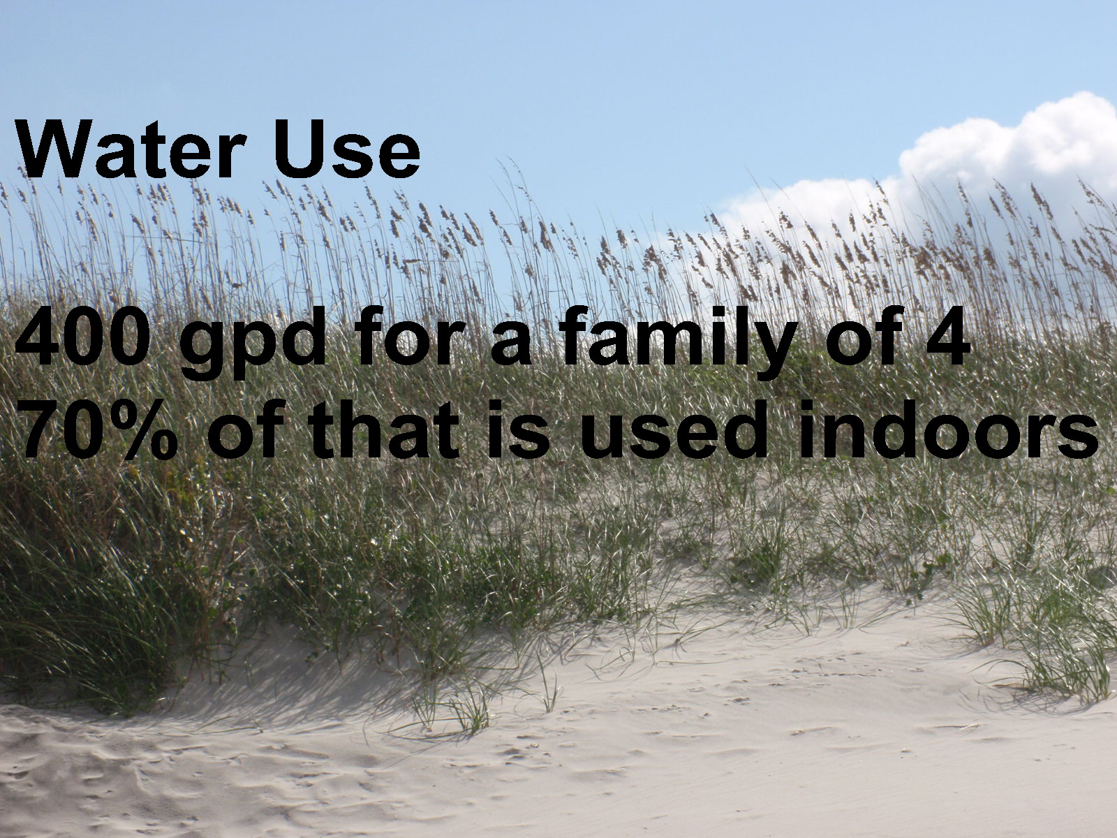
| water use data from http://www.epa.gov/watersense/pubs/indoor.html |
We took what we learned about water use in our everyday
lives. We take our clothes to the
laundromat and flush with salt water, that still leaves 35 gallons per person,
per day, by EPAs numbers. We have 120
gallons of fresh water aboard, it weighs 1000 lbs and that’s a lot for a boat
our size. We make that last 3-4
weeks. We learned to take Navy showers –
turn the water on, get wet, turn the water off, soap up, turn the water on,
rinse off. I once watched a secretary in
the office kitchen on the fifth floor wash a coffee cup. She turned on the water full stream and
rinsed every surface, then left the water running while she soaped every
surface, then rinsed the cup very thoroughly … Wow! Like fingernails on a blackboard, and I’m
thinking I could have washed my hair and half my week’s laundry in that amount
of water. It’s kind of what happens once
you get sensitized to it. In the
Bahamas, too, all the fresh water is desalinated sea water, it costs 50 cents
per gallon. Showers are metered, a $5
token gives you 5 minutes.
 |
| at the helm at Black Point, Bahamas |
When we talked about sailing in the Bahamas in
retirement, this is what I visualized.
 |
| at the helm in the Cheasapeake |
Some days reality was more like this.
 |
| Plaindealing Creek anchorage, near Oxford, MD |
I also thought retirement meant sleeping in, in gorgeous
anchorages like this, but when the sun peeked over the horizon the coffee cups
went down and the anchor came up. We had
a lot of miles to make and Old Man Winter was nipping at our heels. On the ocean we could travel day and night,
just set the sails and let the boat do the work, but the price of staying in
sheltered water on the ICW is that it’s more like driving a car and needs
steady attention. It also meant that we
could travel by day only. Not that we
would have wanted to be out late - in any case, the nights were long and cold
and better spent below where we had heat and light.
 |
| background photo: Atlantic Beach, NC |
Some trip statistics.
 |
| photo from: http://www.sail-world.com/USA/Intracoastal-Waterway-'Now-Dangerous/24004 |
The ICW – Intracoastal Waterway, is a system of rivers
and bays linked by manmade canals, creating a sheltered liquid highway to Miami
(and its counterpart along the Gulf Coast to Texas)
 |
| slide from: http://www.capca.net/pdf/aiwa%20presentation.pdf |
It serves 10 major ports, 14 military bases, 4 Coast
Guard stations. It is used by commercial
transport, which is why its nicknamed the liquid highway, also shared with
fishing and recreational vessels.
 |
| photo from BoatUS.com |


When I worked with Celso, I had an elevator speech about
my job: I reviewed environmental documents for high-profile projects like Star
Wars missile defense system, oil drilling in Alaska, … and every road and
bridge in America. It gave me great
factoids for cocktail parties. When we
were traveling, though, it was fun to see those EISs in action. Bridges over the ICW had to be 65 feet tall
or they had to open. Why? I wondered while I was doing the reviews. Do they think a giant tsunami is going to get
the roadway wet in Ohio? No, it was just
about people like us, and our mast, if you remember the earlier photo of the
bridge opening. It’s always interesting
science and public policy to balance the esthetic and historical factors of
these bridges with the transportation and practical aspects.

Also if you remember from the earlier slide, achieving 12
feet of depth means dredging. In places
like the Indian River in Florida or Currituck Sound in North Carolina, they
could be ½ or 1 mile wide but only 3 feet deep except for a skinny strip down
the middle. It looks like this.

After 7 years of staring at brake lights on the Beltway,
I thought I was done with this staying in line thing.

It’s also scary to see this just a few boat lengths away
– we need five feet of draft, he’s happy with five inches.

You can’t tell where the channel is from the surface and
it’s too inexact for GPS, you use daymarks and a depth sensor on the boat.

Some daymarks are easier to spot than others.
 |
| At the lock, Dismal Swamp Canal, at the low (entry) elevation |
 |
| Same location after we'd been lifted to the high (exit) elevation |
This is a typical lock, used to raise a boat over an
obstacle. It’s a section of the channel
with a gate on each end. You open the
lower gate and sail in, then close the gate and they pump water in to bring you
up to the level of the upper water, then open the lock and you sail on out. There’s also a water quality lock connecting
the Elizabeth River near Norfolk, Va (salt water with 3 feet of tide) with
Currituck Sound (fresh water). Sometimes
the river is higher and sometimes the sound is higher so the gates go both
ways. Originally when the levels were
equal, 4 times per day at mid-tide, they left the lock gates open so boats
could travel freely. By the mid-1930s
they noticed the salt water effects on the fresh water ecosystem – remember
this was pre-EIS, when they did environmental impacts by trial and error – and
they devised the present system.


Moving right along … here we are in the cypress swamps. We had heard about this tea-colored water;
here’s the bow of a boat traveling through it – looks odd.
 |
| A bucket of the tannin-colored water |
 |
| Really! This is NOT a bottle of iced tea! |
We stopped for the night and as any self-respecting
hydrologist would do, collected some of that odd water. It’s no coincidence it’s called
“tea-colored;” the same tannins that make your tea brown and astringent are
present here. They come from decomposition
of the peats and plants here in the swamp.
It looks funky, but is actually fine; the water is acid and the tannins
bind to protein. This water was highly
prized as drinking water in the old sailing days (pre-Clorox) because it didn’t
go foul in barrels on ship on a long sea journey. Couldn’t bring ourselves to try it though!


Just a sense of the variety of terrains we traveled
through.
 |
| Osprey on daymark; photo from : http://svjeorgia.blogspot.com/2012/06/chesapeake-bound.html |
We could do a whole talk on how wildlife adapt to the presence
of humans and human artifacts for their own benefit. This daymark makes a great nesting site for
the osprey, gives him a good perch for fishing and predators can’t sneak up on
him.

Here’s a cormorant drying his wings.

And a heron who decided we were a great fishing perch.
 |
| Crabber in North Carolina |
 |
| Small fishing/crabbing boats at a dock |
We were interested to learn how much accidents of
geography affect development of culture and history. The Carolinas are alike in name only. South Carolina got all the good deep harbors;
think Charleston and Beaufort. North
Carolina has shallow shifting sands and tricky inlets. So North Carolina got the quirky little towns
and fishing boats like these; South Carolina got the commerce and wealth.
 |
| Gate and courtyard in Charleston, SC |
 |
| House in Beaufort, SC |
 |
| Fountain in Charleston, SC |
These photos are what you think of when you
think of the South, right? Conversely,
the only person North Carolina’s shallow harbors were good for was Blackbeard –
he could run his little ships in where the Navy’s larger deeper draft ships
couldn’t follow. So, South Carolina got
the plantations, North Carolina got … the pirates.

Okay, now we’re down to Georgia. The coast here is flat and intricate – the
state has only 100 miles of coastline but the ICW takes 130 miles to go around
these sea islands. The meandering rivers
are connected with the shortest canals possible, so sometimes you go downstream
on a bend of one river that will link up with a loop on the next river and you’re
going upstream there. It’s also tidal –
there are 8-9 foot tides here twice a day.
The Army Corps of Engineers doesn’t dredge here, basically they say that
you can get your 12 feet if you just time your passage to coincide with high
tide. All of which adds up to a tricky
job for the helmsman. (Jaye is the
navigator, tells when and where the tides would allow passage; Dan picks our
way through the channel. Strategy and
tactics. For safety’s sake, both of us can do either job after a fashion, but
we also have our preferred positions and greatest expertise.)
 |
| Streamgaging. Image from USGS |
Who remembers this? Remember looking for a straight,
uniform section to take measurements? No
such thing in this part of Georgia, it’s all meanders.
 |
| diagram from: http://www.indiana.edu/~g105lab/images/gaia_chapter_12/meander_formation.htm |
 |
| diagram from: http://www.indiana.edu/~g105lab/images/gaia_chapter_12/meander_formation.htm |
The theory says the deeper faster water scours the
outside of bends, so Dan would look here for passage. The slower, calmer water is on the inside,
this is where we’d prefer to anchor for a restful night.
 |
| photo from: http://www.atlintracoastal.org/assets/documents/AIWW%20Challenges%20in%20Georgia%2011-15-2007.pdf |
Here’s how that plays out on the ground. You see the fishing boat in the outside bend
going around the daymarks where the deeper water is, the inside of the bend is
dry here at low tide. Another example of
hydrology theory being relevant in retired life!
 |
| photo from: http://www.atlintracoastal.org/assets/documents/AIWW%20Challenges%20in%20Georgia%2011-15-2007.pdf |
Here’s what it looks like, by the way, when you get it
wrong. These guys must have anchored
inside the bend at high tide and then the water went out.
 |
| Bryan Creek, GA |


The Georgia low country terrain is mostly marsh grass and a few trees, in its
way it reminds Dan of the wheat fields on his Dad’s farm in Kansas.
 |
| photo from: http://www.amusingplanet.com/2012/03/tides-at-bay-of-fundy.html |
I mentioned tides, what’s up with that. This photo isn’t the ICW, it’s the famous Bay
of Fundy, some of the highest tides in the world, as much as 50 feet. And while this is extreme, I said tides in
Georgia were 8-9 feet, the Virginia coast and the Bahamas have 3 feet, and here
in the northern Chesapeake it’s only 1 foot.
Why the differences?
 |
| photo from: http://www.wbdg.org/resources/oceanenergy.php |
Turns out it’s a resonance phenomenon, and both the shape
of the bay or coastline and its depth play a part. Tides are lunar with a 12-1/2 hour
period. So, if the time it takes for a
bay to fill or empty is a multiple of
12-1/2, the effects will build on each other and amplify each other and you get
big tides. Just like if you – or your
grandkids – slosh water in the bathtub with just the right frequency, water
will go over the lip and splash on the floor.
Conversely, you can have a section that fills or empties in an interval
that is off-cycle to the tides, there the effects will cancel each other out
and you get small tides.
 |
| photo from: http://en.wikipedia.org/wiki/Amphidromic_point |
You can even have areas with no tide at all as shown on
the nodes on this figure. In this case
the 1-foot tides in the upper Chesapeake is a bad example because it is
constrained by flow through the relatively narrow mouth of the Bay.

Remember those pretty, pristine rivers I showed
earlier? Here’s the more developed part,
in south Florida; note the channels everywhere and hard walls. Boaters refer to this as the canyon, and if
another boat passes you the wakes reverberate, bounce back and forth off these
hard walls and rock you pretty strongly.
A good illustration for the power of shoreline vegetation to dampen the
energy of storm surge.


Anyway, we survived that and here we are south of Miami
the night before our big passage across the Gulf Stream.
 |
| photo from: http://www.fastcodesign.com/1669361/better-than-a-van-gogh-nasa-visualizes-all-the-worlds-ocean-currents |
This looks a bit like psychedelic art from the 60s but it’s
just a great NASA image showing the relative strength and direction of ocean
currents. And here’s the Gulf Stream, a
current of clear warm water that starts in the Caribbean, wraps around the
coast of Florida, up the U.S. East Coast, then hangs a right and heads over to
Europe. One thing this figure explains
is why the water in south Florida is pretty and clear like in the Caribbean,
instead of the dark greenish-black Atlantic water further north up the
coast. Its actually something of a
desert, lacking the plankton and other basic nutrients present in our cold,
dark green water that’s the basic food for ocean life. The other thing, is this is feared as one of
the more boisterous ocean currents, there could be 4 knots running through
here. That makes sense at a place like
this pinch point between Hispaniola and Puerto Rico where a lot of ocean water
squeezes between 2 largish islands, but why here near Miami?
 |
| photo from: http://www.discover-eleuthera-bahamas.com/bahamas-airlines.html |
These Bahamas islands are little and low. But the deep ocean in this satellite photo is
more than 1 mile deep and it’s an unbelievable resonant shade of pure blue that
does for your eyes what a gong or chime does for your ears, a single perfect
note. The light blue here is the Bahamas
banks, about 20 feet deep. So that
explains the Gulf Stream’s power here, because again, it’s a lot of water
squeezing through a small opening. But
how did we get what amounts to a towering cliff in mid-ocean?
 |
| from Bahamian Landscapes (third edition) by Neil E. Sealey |
These islands are young, only about 200 million years
old, and all the sediments in this mile-high underwater plateau come from a
shallow depositional environment. (If
you know what oolitic limestone is, you can take a snooze for a minute or
two.) To hyper-simplify, we have a ring
of coral that is growing at exactly the rate that the ocean floor here is
sinking. The waves slosh over into the
basin, warm up, some water evaporates and now it’s saturated, super-saturated,
and precipitates tiny pellets or seeds of calcium carbonate, which became the
islands and their banks. The ocean kept
sinking and the coral kept growing. This
is the “bucket theory: coral walls and sediments in the middle.
| at anchor at Andros Island |
I understand the secchi depth here can be as much as 200
feet – wow. Here’s our boat anchored in
Andros Island, the water is so clear you can see us floating over our own
shadow. This was our first stop in the
Bahamas, our first exposure to this water.
I’m lowering the dinghy and suddenly there’s a problem, there’s no
weight on the line but I can see that the dinghy is still in the air. Call Dan over; we realize that there’s no
weight because the dinghy is not in the air, it’s floating on water so clear we
can’t even see where air ends and water begins.
 |
| beach at Highbourne Cay, Exumas, Bahamas |
The old-timers could use the color of the water to estimate depth. "If it's blue, sail on through; if it's green, gettin' lean; if it's brown, you go aground."

This is the texture of some of that limestone rock on
Warderick Wells, as you can imagine, hiking is challenging. Some of the cementation is dissolved away
here, the Bahamians call these musical rocks, they ring if you bang them
together.

These mini-islands are called cays (like Florida Keys but
spelled cay in the rest of the Caribbean).
These are at low tide, look at the erosion at the rims, at high tide
they look like ordinary small islands, at low tide they look like little
mushrooms in the ocean. This is the
Thunderball grotto from the James Bond movie of the same name.

Let’s talk about karst! These are sinkholes and collapsed
cavern roofs. Here’s one on Andros. When these are dry they are called banana
holes, they collect what little precip there is and shelter the trees that grow
in them from the prevailing trade winds, so you get pockets of very vigorous
vegetation. If they are deep enough they
connect to the ocean water, this one just looks like a picnic lake but
rises and falls with the tides and has ocean fish in it. The deepest one measured in the Bahamas is
over 600 feet deep.
 |
| from Bahamian Landscapes (third edition) by Neil E. Sealey |

They can also be in shallow water, there they are called
blue holes. We have a glass-bottom
kayak, its fun to paddle over these because of the abrupt change in depth. Also came upon a lemon shark when snorkeling
here.
 |
| Background photo: beach at Compass Cay |
 |
| photo by Magda Galambos |
(Wrap up and questions)
No comments:
Post a Comment